

Explanations & Tutorials
How Does GPS Work? - 6 Things You Didn’t Know
At a high level, I thought I understood how GPS works. Turns out I was wrong, so here's how GPS works and 6 things you probably didn’t know.
At a high level, I thought I understood how GPS works. Turns out I was wrong, so here's how GPS works and 6 things you probably didn’t know.
The Global Positioning System (GPS) is critical in enabling many of our technologies. GPS allows us to get accurate directions while we drive, helps emergency responders to quickly find callers, tracks how far we ran during a workout, and much more. But despite how ubiquitous GPS has become, and how essential it is for so many technologies we’ve come to take for granted, I realized that I couldn't answer, how does GPS work?
At a high level, I thought I understood how GPS works. Satellites transmit their location, and by using three of them you can solve for your own location in 3D space. That's how GPS works, right?
Turns out I was wrong, so here's how GPS works and 6 things you probably didn’t know.
GPS is just one of several space-based radio navigation systems. Russian has its GLONASS system, the European Union has its Galileo system, and China has its BeiDou system.
However, the Russian GLONASS is the only other system that offers global coverage, though slightly less accurately than GPS. The Galileo system is expected to reach global operational capacity by 2019, and BeiDou by 2020.
Space-based radio navigation systems are essential to most military applications, so countries don’t want to be reliant on another country if hostilities occur. The Indian military learned this the hard way in 1999 during the Kargil War when they were selectively denied access. By who you ask?
Like many modern technologies, GPS was born out of the military during the Cold War. Nuclear deterrence was the name of the game, which meant the capacity to launch nuclear weapons at the enemy’s homeland.
Nuclear submarines can approach a coast in stealth, close enough to fire a submarine-launched ballistic missiles into the mainland. However, to fire a ballistic missile accurately from a submarine, it’s critical that you know exactly where that submarine is located. GPS was thus meant as a better navigation system for those submarine-launched ballistic missiles.
Although the Cold War had ended 4 years prior with the collapse of the Soviet Union, GPS became fully operational in 1995. At first, the highest quality signal was reserved for military use but in 2000 GPS was made freely available to the public as a national resource.
To achieve global coverage for GPS, 24 satellites are required. The first of the 24 was launched in 1989 and the 24th was launched in 1994.
GPS satellites only last about 10 years, and often need servicing during their lifetime, which is why there are currently 32 GPS satellites in orbit. The extra satellites fill in the gaps when the core 24 satellites need to be serviced or decommissioned, so that coverage is maintained.
But why are 24 satellites needed in the first place?
Using a constellation of 24 GPS satellites ensures that at least 4 satellites are within line-of-sight of any location on Earth at all times.
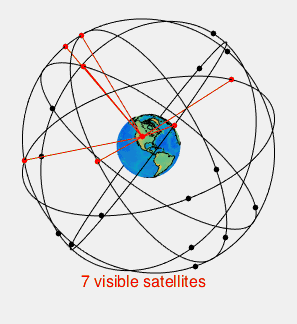
The magic number is 4 because of the way that GPS calculates your exact position. Each satellite sends out a signal that includes 1) the exact time that the signal is sent and 2) the exact position of the satellite relative to the center of the Earth.
We know that the speed of light is constant, so the time it takes for the signal from a GPS satellite to reach you, multiplied by the speed of light, is the distance between you and the satellite. We also know the positions of each of the satellites, so by doing a little geometry, we can use the satellite locations and the known distances to figure out our own location.
“But wait”, you say, “if I remember my high school math, you only need three equations to solve for three unknowns. Why do we need a fourth satellite?”
That’s because there’s a fourth unknown. We don’t actually know the exact time it took the signal to travel from the satellites to you. That’s why…
According to Albert Einstein’s general theory of relativity, time moves faster for objects that are further from sources of gravity. Because satellites are further from Earth, their onboard clocks run 38 microseconds faster per day than clocks on Earth’s surface.
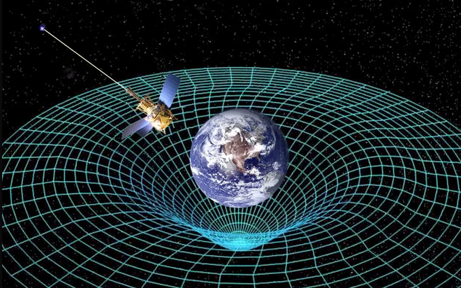
Without corrections, this would mean that GPS locations would be off by as much as 6 miles per day.
So the fourth unknown variable is the time deviation from the atomic clocks on the GPS satellites. This is why 4 satellites are needed to determine precise location. However, one of the benefits of this system is that…
The accuracy of GPS time signals is within 10 billionths of a second, which is second only to atomic clocks themselves. So GPS is also used for determining exact time, which is extremely important for time-critical applications.
Our cellular networks, banking systems, financial markets, and power grids all depend heavily on GPS for precise time synchronization. In the communications sector, GPS timing allows synchronized call handoffs. In the financial sector, GPS timing allows for financial transactions to be accurately timestamped.
The precise location and timing ability of GPS is a critical enabler to many IoT applications. From precision agriculture, to automated vehicles, to fleet tracking, to smart mining, and many many more.
So hopefully you can now answer, "how does GPS work?", and know a little more about this amazing technology that has quickly become a necessary and ubiquitous component of our everyday lives.
Join companies like Cox Communications, Yamaha, and Google who have selected Leverege to launch innovative IoT-enabled asset management applications to optimize operations, increase revenue, and delight customers.

Thanks for submitting your information. Our team will be in touch soon.

Skip the complexity of IoT and get highly configurable IoT applications tailored to your business.


.svg)

